Introduction
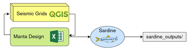
Manta Design is PXGEO’s specific survey design tool for Ocean Bottom Node operations.
An OBN project involves deploying seismic sensors on the seafloor—known as Ocean Bottom Nodes—to collect high-resolution seismic data for subsurface imaging.

Manta Design is composed of a series of PXGEO internal resources, such as the Sardine code, the MantaDesign excel and Macros and the Seismic Grids QGIS plugin. Some external resources such as QGIS are also used in the workflow.
QGIS is a free and open-source Geographic Information System (GIS) application used for viewing, editing, and analyzing geospatial data.
These tools combined provide the commercial experts of PXGEO with a way of planning an OBN project from a client’s list of requirements. After Manta Design’s workflow, the commercial person in charge is able to present the client with a plan for their project. The outputs obtained are also used as a tool for estimating the costs and duration of each survey.
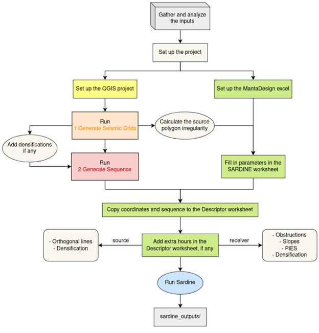
To make these estimations and get the outputs of an OBN project, there is an existing workflow that is followed by the commercial experts. In this document we intend to describe the basis of this workflow as best as possible. Note that the information is not complete, and that the arise of specific needs during the planning of an OBN project is quite common, requiring the user of MantaDesign to replan and add extra steps to the general workflow.
- Some notes and corrections regarding OBN workflow:
The QGIS part of the workflow may also include identifying any obstructions or features that would slow the work, such as platforms, flow lines, exclusion zones, FPSOs, seabed slopes, high density marine traffic areas, wildlife protection areas, etc. Additionally, the workflow also needs to allow for the adjustment of the sequence to meet the project needs, right after “Run 2 Generate Sequence”.
Although the current workflow of the sequence generator is currently implemented in QGIS as part of the ‘seismic grids’ plugin, it was previously part of the MantaDesign excel workflow as part of the Sardine code. It was not until the release of seismicgrids version 1.0 and Sardine version 0.7.0 that this utility was upgraded and oved to QGIS.
Other reasons exist for adding extra hours aside from the ones listed above. One common use is to open gaps in the timeline, for example in the case of a crew change. Some of these specific cases should not be necessary after the release of version 0.8.3 of Sardine, which allows for crew changes, multiple vessels and different work intervals to be added without the need for extra hours as a hack.
The workflow of Manta Design and its internal processes are a work in progress, meant to be the tools that optimize the planning of the surveys and thus saving time and money. We may expect changes and improvements in the workflow in the upcoming years.